LiDAR Mobile Mapping Systems

Mapping & Rugged Positioning, Navigation and Timing Solutions.

A broad array of precise Positioning, Navigation and Timing (PNT) solutions designed to address a wide range of requirements for Air, Sea and Land, including high speed pointing/attitude and relative position/angle applications.

Robustly engineered, self-contained systems, that are simple to operate and enable a rapid deployment in the field. The PNT products are designed to provide critical PNT information under demanding conditions.

Compatible Software products- including software toolbox, visualization and analysis tools specially developed to help you handle your resulting PNT data easily and quickly.

Applications are as diverse as the platforms using this information ranging from PNT for stationary or slowly moving platforms such as Aerostats to PNT for high-dynamic aircraft and everything in between.

Our leading mobile mapping solutions include the Aevex Geodetics Geo-MMS , Point & Pixel, the Routescene LidarPod® and the SatLab Apus UAV Lidar based solution.

GEODETICS IS NOW a part of AEVEX AEROSPACE.


Quotation Request

GEO MMS

Geo – MMS

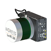
Geo-MMS is a fully integrated LiDAR mapping payload for integration with small unmanned vehicles. The Geo-MMS includes an inertial navigation system coupled with a LiDAR sensor. Raw data from the integrated GPS, IMU and LiDAR sensors are recorded on the internal data recording device and can be post-processed using Geodetics’ LiDAR tool software package to directly geo-reference the LiDAR point clouds with LAS format output. Geo-MMS is available with a wide range of sensors.

Key Features:

  • Flexible mounting for different platforms including UAV, UAS, ground vehicles and robots
  • Minimized sensor size and weight to meet payload restrictions (5 pounds minimum payload)
  • Available with a many IMU’s to support a wide range of application requirement
  • Centimeter-level position accuracy (dual-frequency RTK configuration)
  • On-board data logging of all raw and navigation solution data
  • User interface to fully control individual and collective GPS, IMU, Laser setting
  • Full post-processing support with GPS/IMU Geo-PostProcessing
  • LAS file output
Point&Pixel

Point&Pixel™ – Combined LiDAR and Photogrammetry

Point&Pixel combines the best of Geodetics’ Geo-Photomap and Geo-MMS LiDAR products by integrating LiDAR point clouds with Photogrammetry and delivering stunning colorized LiDAR point clouds.

Key Features

  • Combines LiDAR and Photogrammetry point clouds
  • Enhances visualization
  • Enables LiDAR point cloud colorization
  • Enhances DTM/DEM extraction
  • Facilitates LiDAR point cloud classification
  • Orthophoto generation in areas Photogrammetry fails (i.e., glaciers, tree canopy, mine site conveyors, etc.)
  • Change detection (2D, 3D, 4D)