GNSS Receivers

For utility companies, municipalities, land surveying, environmental management agencies, construction companies, and many other organizations accurate information is vital.

Trimble GNSS receivers are a flexible positioning solution for productive and accurate GIS data collection. With the freedom to choose from a range of configurations, Trimble GNSS receivers provide timely and accurate data for decision-making and integrate seamlessly with industry-standard GIS systems and professional GIS data collection workflows.

Datasheet for Trimble GIS Hardware Product Comparison

Quotation Request

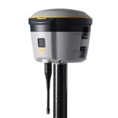
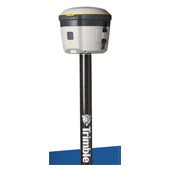
Trimble R580 GNSS STSTEM

Trimble R580 GNSS receiver is a compact, cable-free design with an integrated GNSS antenna, military-grade rugged design, IP65 rating.


The R580 with the Trimble Maxwell™ 7 technology anti‑spoofing capabilities includes the Trimble® ProPoint® GNSS positioning engine for improved accuracy and productivity in challenging GNSS conditions is a dependable integrated receiver to meet your everyday high accuracy needs.

Key Features:

  • Trimble Maxwell™ 7 technology anti‑spoofing capabilities
  • Trimble® ProPoint® GNSS positioning
  • Trimble IonoGuard™ technology
  • Trimble CenterPoint® RTX corrections via satellite or internet
  • Supports Trimble xFill® correction outage technology
  • Receive-only 450 MHz UHF radio
  • Compact, cable-free design with integrated GNSS antenna
  • Centimeter level position accuracy
  • Rechargeable, removable Lithium-ion battery in internal battery compartment

Trimble DA2: GNSS RECEIVER FOR THE TRIMBLE CATALYST SERVICE

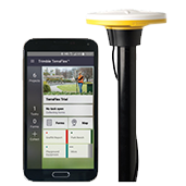
Trimble® Catalyst™ is a revolutionary GNSS concept delivering positioning-as-a-service to mobile devices. With the addition of a simple, lightweight GNSS receiver and an on‑demand accuracy‑based subscription, turn your Android or iOS device into a powerful centimeter-accurate mapping, navigation, and measurement tool you can use with any location-enabled app or service.

Key Features:

  • Simple, precise, submeter-to-centimeter GNSS accuracy
  • Scalable and flexible accuracy-based pricing
  • Lightweight and rugged design
  • Simple installation and setup
  • Multi-frequency (L1/L2/L5/MSS) capable
  • Powered by Trimble ProPoint™ GNSS positioning technology
  • Supports all global GNSS systems
  • Flexible mounting options
  • Connects wirelessly to iOS and Android™ devices
  • Conveniently USB powered
Trimble-catalyst1

Trimble Catalyst

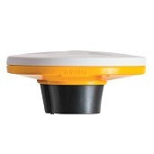
Trimble Catalyst is a revolutionary new offering from Trimble that introduces a software defined GNSS receiver that runs on select Android phones and Tablets. It requires a specialized digital antenna (Catalyst DA1) that connects to the Android device via USB. The solution enables a customer to subscribe to the Catalyst service in order to enable the GNSS receiver to operate at a level of accuracy related to their subscription level.

Key Features:

  • Comprehensive GNSS support, including GPS Modernization signals, GLONASS, BeiDou and Galileo
  • Robust low-elevation satellite tracking
  • Minimized multipath
  • Sub-millimeter phase center repeatability
  • Ideal for fixed reference stations and GNSS infrastructure networks
  • Now with Iridium and Japanese LTE filtering

GNSS receivers for professional data collection

A winning combination of high accuracy with real-time positioning, truly taking GIS data collection to a new level. No matter where in the world you work, the GNSS receivers give you a complete real-time and a flexible positioning solution for productive and accurate GIS data collection. With the freedom to choose from a range of configurations, Trimble GNSS receivers provide timely and accurate data for decision-making and integrate seamlessly with industry-standard GIS systems and professional GIS data collection workflows.

R2 GNSS Receiver – EOL

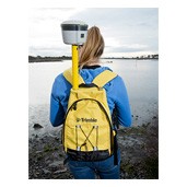
The Trimble R2 is a compact, durable GNSS receiver that provides an easy-to-use solution for GIS professionals who need to collect highly accurate data in applications ranging from mapping and locating underground infrastructure, such as pipes and cables, to inspecting storm water drains, and much more.

  • Professional solution for GIS applications ranging from submeter to centimeter accuracies
  • Easily collect data by pairing with devices such as smartphones, tablets or Trimble handhelds
  • Gives you total flexibility to choose a solution based on the accuracy and GNSS performance level that suits you
  • Fast to setup, easy-to-use, keeping you productive and focused on your work
  • Supports multiple satellite constellations and correction sources for accurate data at any location
  • Trimble Maxwell 6 chip with 220 channels and leading GNSS technology maximizes data quality